Application of PC GS Pro in plant protection operation
In many industries, access to geographic information is the key to doing business. Whether it is surveying, agriculture, security, electricity, construction, land monitoring, work planning based on geographic images is required. Converting images acquired by drones into usable geographic information has been time consuming and expensive. DJI has launched a new PC GS Pro ground station software that integrates route planning, autonomous operation control and mapping to provide a convenient and efficient one-stop mapping solution for industry users.
Real-time mapping
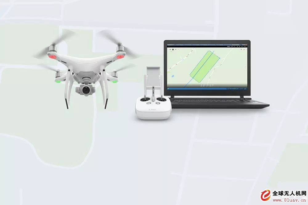
PC GS Pro has route planning and autonomous operation control functions. Set the waypoint or work area on the map, set the waypoint action and other operating parameters to control the drone to perform autonomous work.
In the absence of PC GS Pro, after the flight is completed, it is necessary to import the aerial image into the computer and use other software/services to make the drawing. It takes hours or even days to get the result. Timeliness is weak and the operation is complicated. With the PC GS Pro, you can make a map while flying. In other words, a two-dimensional orthophoto image of the work area can be obtained immediately at the end of the flight.
The ability to build maps in real time provides efficiency and flexibility for work, allowing work that previously required multiple round trips to be completed on site once. In addition to real-time mapping, PC GS Pro also supports post-processing, importing and splicing images stored on the drone SD card for higher image accuracy.
Since it does not require network support, PC GS Pro can be widely used in the field of lack of network in the field, in addition to plant protection planning. For example, after the earthquake, rescuers can estimate the disaster situation and formulate a disaster relief plan. The PC GS Pro can not only map the disaster area, but also clearly show the damage of buildings and roads, and provide guidance for rescuers.
In land monitoring applications, high-resolution 2D mapping using PC GS Pro provides a clear view of building and land use. Regular construction of the map and comparison of images from different periods can detect illegal construction in a timely manner. In the power line inspection, the construction of the map can identify potential hazards such as tall pole plants and illegal buildings in the wire passage. Compared with the original images taken by drones, 2D drawings are easier to query, measure, label and archive, which can greatly improve work efficiency.
Easy to use
PC GS Pro is easy to operate. After opening the software, you can select the area to be built. We use the farmland planning plan with a flying height of 100 meters and 500 acres to illustrate the drawing process.
1. Basic parameter setting: perform real-time mapping - after completing the action, you can choose according to actual needs (hover, auto return, in-situ landing, return to the starting point hover) - flight altitude (100m) - flight speed (use recommended speed 10m) /s);
2. Advanced settings (need to set the image overlap rate between the main routes 70% - the image overlap rate on the main route is 80%), other settings are not required;
3. Camera settings: Camera model (P4R/P4P/P4A can be selected according to the actual model), the photo ratio is 4:3, other settings are not required;
4. After the setting is completed, you can click to start flying;
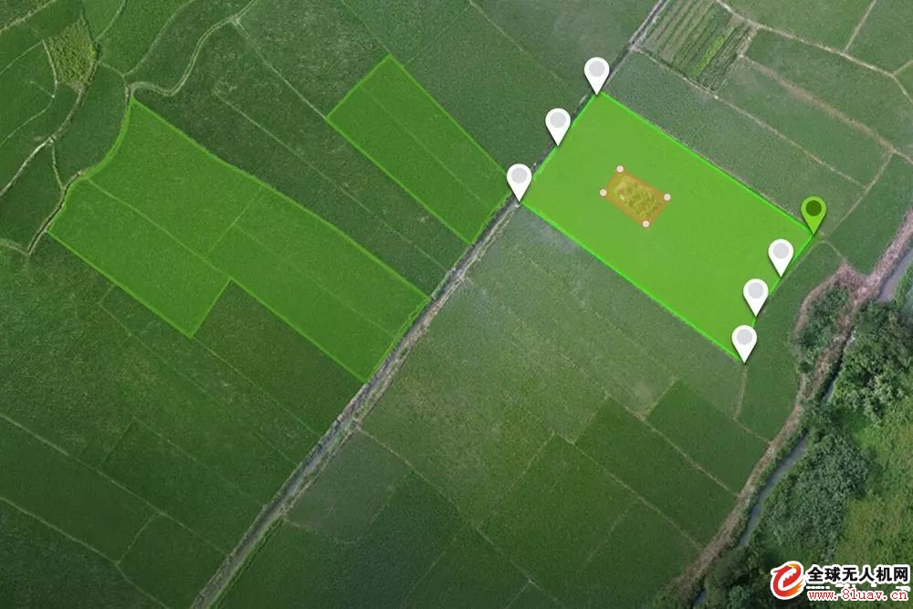
After the farmland image is quickly generated, it can be directly planned on the PC GS Pro, such as farmland boundary setting, obstacle marking, calibration point marking and other complete planning functions to fully meet the user's operational needs. After the plant protection task is edited, it can be directly imported into the plant protection machine remote control to carry out the plant protection task.
Rame>
Plant protection operation planning demonstration
PC GS Pro recommended computer configuration
PC GS Pro supports Windows 7 or higher or 64-bit systems. Computers using PC GS Pro also need to meet certain hardware configuration requirements in order to smoothly use advanced functions such as 2D mapping in software.
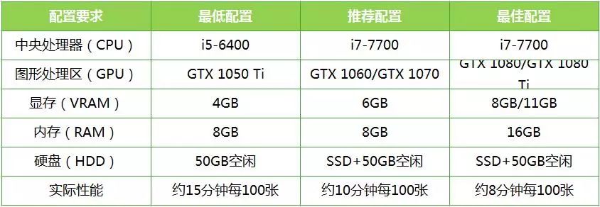
* Take the processing speed when using aerial photographs with a flying height of 100 m (the generated ground sampling distance is 0.1 m) as an example.
* Actual use of real-time mapping function can be run on a computer without CUDA support (non-NVIDIA graphics card), but the accuracy and reliability of mapping are low. It is recommended to use the computer with the above minimum configuration. Importing pictures requires graphics card to support CUDA. .
PC GS Pro support models
The PC GS Pro can be used with the Sprite 4 RTK to easily plan your drawings with precision-positioned RTK, 1-inch 20-megapixel CMOS, and OcuSync 2.0 HD digital image transfer technology. In addition to this, PC GS Pro also supports Wizard 4 Pro and Wizard 4A.
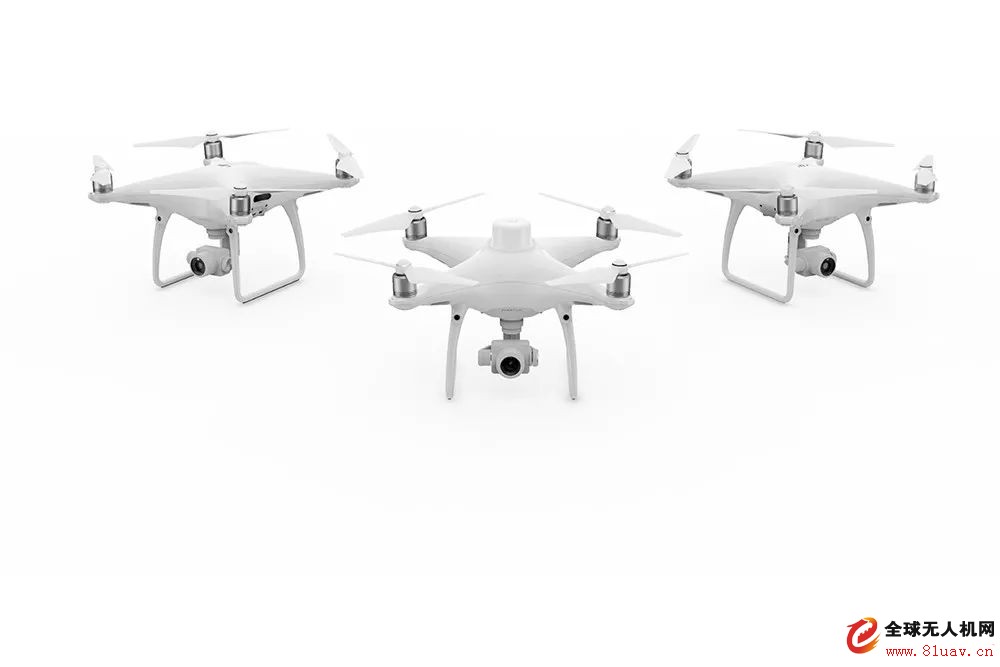
PC GS Pro and Elf 4 RTK will be released in early 2018, focusing on the application of Dajiang industry, we will push you the latest news for the first time.
Desktop Phone Holder,Desktop Mobile Phone Holder,Adjustable Desktop Phone Holder,Universal Desktop Cell Phone Holder
Ningbo Luke Automotive Supplies Ltd. , https://www.car-phone-holder.com